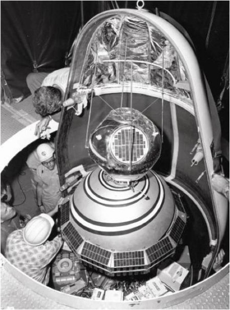
Fifty-two years ago this month, the Transit 2A and GRAB 1 satellites were successfully launched into orbit by a Thor Able Star launch vehicle. This marked the first time that multiple functional satellites were orbited on the same mission.
On Wednesday, 22 June 1960, Thor Able Star 281 roared away from LC-17B at Cape Canaveral, Florida with the Transit 2A and GRAB 1 satellites on board. Both orbiters were designed and developed under the auspices of the United States Navy. Each satellite was successfully placed into its respective target orbit by the powerful hybrid Thor rocket system.
Transit was the first operational satellite navigation system. More formally known as the Navy NAVSAT (Navigation Satellite) System, Transit provided accurate global position data in support of naval worldwide sea operations. The navigation of submarines and surface ships was greatly aided by Transit-provided data as were sundry hydrographic and geodetic surveying programs.
Transit was developed for the Navy by the Applied Physics Laboratory of the Johns Hopkins University (JHU/APL). Work began in 1958 and launch of the first prototype Transit satellite, Transit 1A, took place in September 1959. A number of Transit satellite launches took place over the next 5 years with the system going operational in 1964.
Transit satellites provided position data that was accurate to within about 3 feet. The system revolutionized global navigation and was ultimately used by an untold number of ships and boats. Transit navigational operations ceased in 1996 with the advent of the Global Positioning System (GPS). One of the great benefits of GPS is that position data are provided continuously whereas Transit provided discrete data about once an hour.
The other notable passenger aboard Thor Able Star 281 was the GRAB 1 satellite. GRAB (Galactic Radiation Background Experiment – go figure) holds the distinction of being the first successful Electronic Intelligence(ELINT) satellite in history. Stationed in a 500-mile orbit, its mission was to monitor Soviet radar emissions for the purpose of mapping that country’s air defense radar system. GRAB also monitored electronic activity coming out of Red China and other communist nations as well.
GRAB transmitted reconnaissance information obtained during a data collection pass to special ground stations within its field of view. These data were recorded and found their way to military and civil security agencies for analysis. For obvious reasons, the GRAB program was classified. In fact, it was not until 1998 that the program was declassified.
A confusing aspect of the GRAB 1 satellite is that it is often referred to as the SOLRAD 1 satellite. (SOLRAD stood for Solar Radiation.) This confusion was in fact intentional. The GRAB/SOLRAD satellite in actuality had two scientific packages on board. The publicly-known entity was SOLRAD. As the name implies, its purpose was to gather solar radiation data. Its alter purpose was as a front for the clandestine ELINT mission of the GRAB package.
The dual mission of the GRAB/SOLRAD 1 satellite was very successful. GRAB ELINT operations took place over a 3 month period and included a total of 22 data collection passes over denied territory. In its 10-month operational mission, SOLRAD gathered an extensive amount of solar emissions data which, when correlated with ground measurements, added significantly to our understanding of the Sun.

